SEAFOOD 101
The Blob—Warm Ocean Waters off
our Coasts
What is the Blob?
In the fall of 2013 a pattern of high pressure over the Gulf of Alaska reduced
the loss of heat from the ocean to the atmosphere creating a large pool
of warmer than normal water in the center of the Gulf of Alaska. It was
nicknamed the Blob by Washington State climatologist Nick Bond.
In 2014, the warmer water made its way south towards Northern California
then all the way to Baja. This water was about 3 to 4 degrees Celsius warmer
than normal. The warmer water continued off the U.S. west coast through
the summer of 2015 and has cascading effects on land and in the ocean.
Is this part of a normal climate pattern?
• Two climate events are currently taking place — the Pacific Decadal
Oscillation, a 20–30 year climate pattern, is shifting into a warm phase
in the North Pacific; and an El Niño, which happens every three to
seven years, is forming in the equatorial Pacific. Both have been shown
to impact global weather patterns.
• The blob, or the extreme warm waters off our coasts, are at the extreme
end of the natural range of variability seen historically, but scientists warn
these events may happen more often due to climate change.
What changes are scientists
seeing in marine waters off the
U.S. west coast and Alaska?
•
Shifting food webs:
Tropical species
from plankton to whales are being
found further north than normal. A
chartered NOAA research vessel
40 miles off Icy Point Alaska caught an
ocean sunfish or Mola mola, Pacific
pomfret, and skipjack tuna. Rare false killer
whales, a tropical species, were reported
in the temperate waters off Southern
California.
•
Starving animals:
In early 2015, two species had unprecedented events—
thousands. Thousands of emaciated juvenile Cassin’s Auklets washed
ashore from California to Washington and hundreds of starving California
sea lion pups were found on beaches in Southern California.
•
Huge algae blooms—off Alaska and the U.S. west coast
: Some of the
algae have produced harmful toxins, causing closures of recreational
and commercial harvesting of shellfish. Scientists are currently
conducting field work to determine if the large blooms are linked
to the blob.
How will the warm water impact fisheries?
• Anglers off California have reported excellent fishing for warm water
species including yellowfin tuna, yellowtail and mahi-mahi.
• Commercial fishermen in Alaska haven’t seen any changes in their
fisheries, but the impact of these warm waters may not be fully realized
until years in the future.
• NOAA Fisheries scientists were on the water off Alaska this past
summer conducting studies and are producing models to better
understand how fisheries may be affected if warmer waters become
the “new norm” due to climate change. To learn more about current
research and other Arctic science, visit the NOAA Fisheries
Alaska Fisheries Science Center website:
How do scientists feel?
Bill Peterson, NOAA Fisheries scientist, summed it up, “For a scientist it’s a
very interesting time because when you see something like this that’s totally
new you have opportunities to learn things you were never expecting.”
Where’s the Blob?
Use the NANOOS climatology app to find out where the blob is:
Link to NANOOS:
/
(click on “What is the blob doing now?” link, use the NCDC OI water temp.
(anomaly), data are summarized by month)
Maps of SST anomalie:
gov/psd/map/clim/sst.shtml
Cool animation of SST anomalies:
. anom.anim.year.html
How do scientists measure
sea surface temperature?
In the past, scientists determined water
temperature by directly taking a sample
of water and using a thermometer. Today
scientists use satellites to determine sea
surface temperature. They get readings
daily and can see when ocean temperatures
are different than normal.
This Mola was captured and released
alive during a research cruise during
the month of July in the Gulf of Alaska.
Photo courtesy of NOAA.
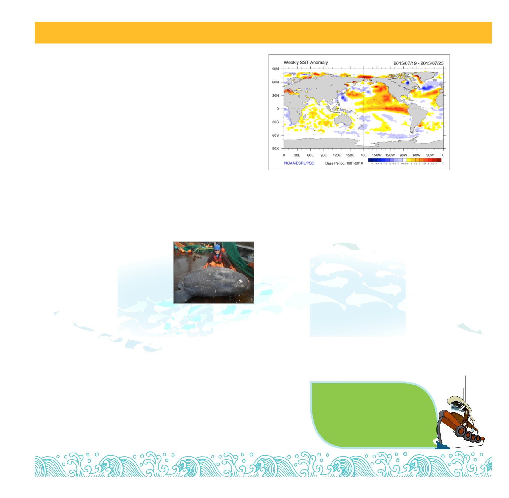
Sea Surface Temperature anomalies for last week of July 2015. Remnants of the blob and the
formation of the El Niño at the equator. Photo courtesy of NOAA.
4
SUNDAY, SEPTEMBER 27, 2015 |
Sponsored Newspapers In Education Content


