2
WEDNESDAY, APRIL 20, 2016 |
Sponsored Newspapers In Education Content
MAKING SENSE OF CLIMATE CHANGE PROJECTIONS
Globally, greenhouse gas concentrations have risen as a result of human activities, and have been a primary driver
of warming. Since it is impossible to predict the exact amount of greenhouse gas emissions resulting from future
human activities, scientists use “what if” scenarios to predict possible future greenhouse gas emissions. These
predictions drive computer model simulations of the earth’s climate. How much and how fast climate changes
occur depends on both the amount of future greenhouse gas emissions and how the climate changes in response
to those emissions.
INCREASING TEMPERATURES
Over the last century the Puget Sound region has warmed, with the average yearly temperature in the lowland
areas increasing by 1.3°F. In all but six years from 1980–2014 the average yearly temperature has been above the
century’s average temperature. Puget Sound’s frost-free season has lengthened by 30 days (between 1920 and
2014), and nighttime temperatures have increased nearly 2°F.
CONTINUING OCEAN ACIDIFICATION
As a result of accumulating carbon dioxide (CO2) in the atmosphere, the waters of the North Pacific Ocean and
Puget Sound are experiencing a reduction in pH, a process known as acidification. Ocean acidification is projected
to continue over the next century, with ocean acidity projected to more than double. Other factors that influence
the pH of marine waters locally include coastal upwelling, river runoff and nutrient runoff.
MORE INTENSE HEAVY RAINFALL
Heavy rainfall events (often caused by “atmospheric rivers”) are expected to become more intense. Climate
models show the heaviest 24-hour rain events in the Pacific Northwest will intensify by an average of 22 percent
and occur seven days per year by the 2080s, as compared to two days per year historically (1970–1999).
RISING SEA-LEVELS
At the Seattle tide gauge, one of the longest-running gauges in the region, sea level rose about eight inches
between 1900 and 2008. Sea levels are projected to increase by an average of 24 inches by 2100 in the Puget
Sound region (range: 4-56 inches). Changes in local land motion, weather patterns, and ocean currents can
amplify or mask regional trends in sea level.
SALMON
Pacific salmon are iconic species of the Puget
Sound region and the Pacific Northwest; they
are critical to the cultural identity of many tribes
of the Coastal Salish people, local economies
for jobs and recreation, and are linked to the
health of freshwater ecosystems. Warmer streams,
ocean acidification, lower summer streamflows,
and higher winter streamflows are all projected
to affect the spawning and survival of Pacific
salmon populations.
Lower streamflows result in physical barriers
to migration when there is not enough water to
migrate back to spawning grounds. The effects
of lower summer streamflow will be worsened
by increasing stream temperatures. Streams
with temperatures that are currently favorable
for salmon could see temperatures increase to
levels considered stressful for salmon (i.e., stream
temperatures >67°F) while streams that already
reach stressful temperatures in today’s climate are
more likely to see temperatures warm enough to
create migration barriers for salmon. As river and
stream temperatures rise, cold water “refugia”
within rivers—areas in the river that are colder
than other areas—and diversity among salmon
populations will be critical to helping salmon
populations be resilient.
We cannot know which scenario is most likely. It is important to consider a range of potential outcomes.
There is no “best” scenario, and the appropriate range of scenarios depends on the specific climate
impact under consideration. Projections will continue to be updated over time. As the science of climate
change progresses, new greenhouse gas scenarios and updated climate models will replace current
climate projections.
Source: UW Climate Impacts Group,
State of Knowledge: Climate Change in Puget Sound
report.
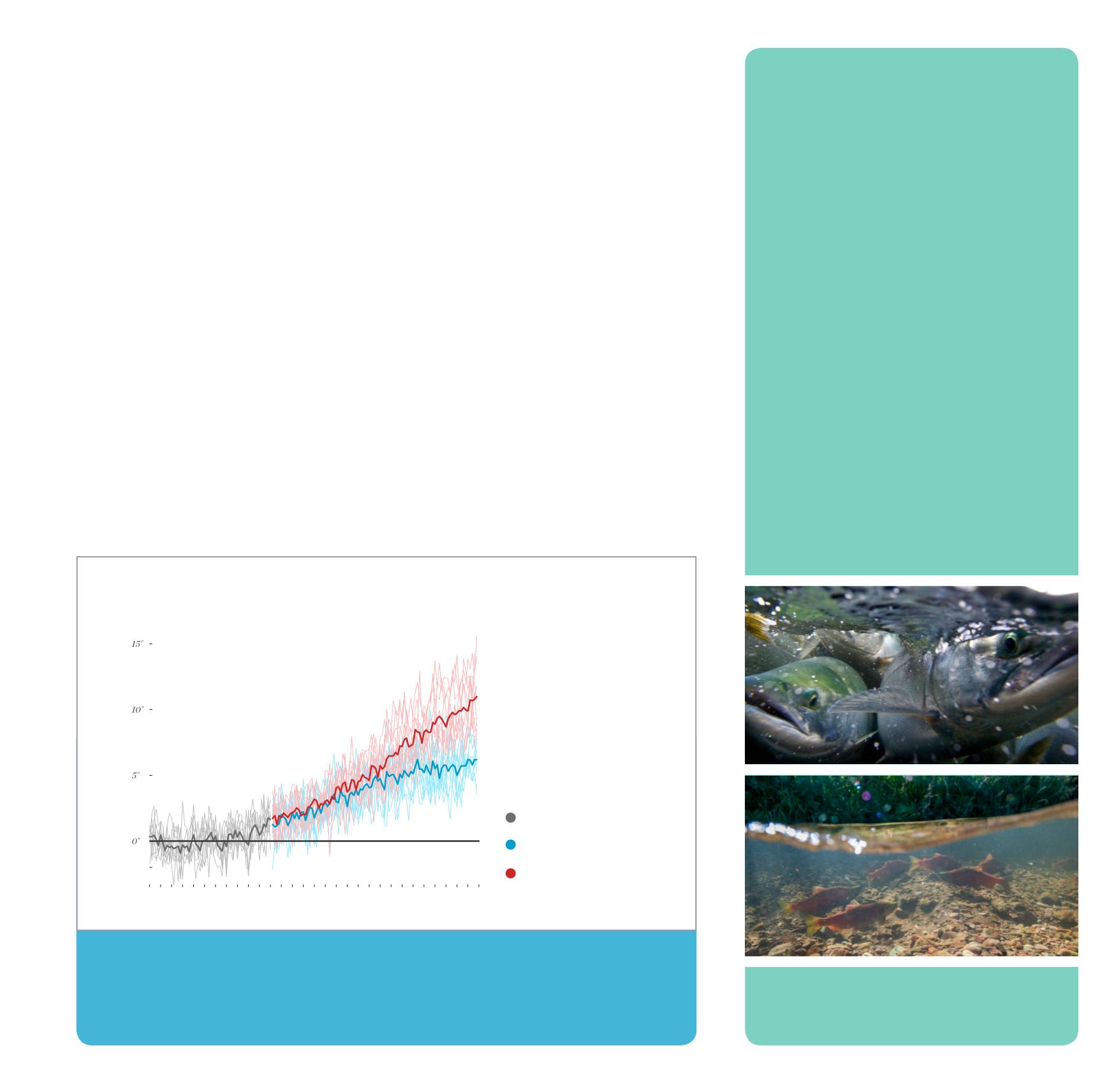
AVERAGE ANNUAL TEMPERATURES IN THE PUGET SOUND REGION ARE PROJECTED
TO INCREASE RAPIDLY IN THE COMING DECADES
{
Temperature difference relative to 1950-1999 average
}
The graph shows average annual air
temperatures projected by climate
models, relative to the average for
1950-1999 (horizontal gray line; the
average annual temperature for the
Puget Sound region is 44°F). Thin
colored lines show individual climate
model projections; thick colored lines
show the averages of the models.
Data source: Downscaled climate
projections
1950
1975
2000
2025
2050
2075
2100
HISTORICAL
LOW EMISSIONS (RCP 4.5)
HIGH EMISSIONS (RCP 8.5)
Change in degree F°
Years
GRAPH BY UW CLIMATE IMPACTS GROUP
Climate is what you expect. Weather is what you get.


